Activity 1: If Mars Had Seas, Where Would They Be?
In this first activity, students will interpret topographic maps of Mars and locate where seas would be located if Mars had seas.
Using colored pencils, students will color-code topographic maps of Mars and compare their maps to a color topographic map of Mars. Students will use the map scale to measure the distance across Hellas Planitia.

Purpose
Students will discover that the northern hemisphere has considerably lower elevations than the highlands of the southern hemisphere.
Objectives
Students will:
- Locate and color all areas below the topographic datum (or sea level, 0-kilometer elevation) on a topographic map to reveal where regions of higher (dry) land would be if Mars had a sea.
- Design and apply a color key to the rest of the topographic map.
- Use the colored topographic map to locate an area below the topographic datum in the southern hemisphere.
- Interpret the map scale and measure the diameter of Hellas Planitia.
Materials
- Metric ruler
- Topographic maps of Mars' eastern and western hemispheres
- Colored pencils
- Color-coded topographic map of Mars
- Tape
Engagement
Begin a discussion:
- What elevation is sea level on Earth? How is sea level measured on Mars? Explain that there are no seas on Mars now, but there may have been billions of years ago. Future Mars missions will search for evidence of ancient seas.
- Ask your students, "If Mars had seas, how would you know? What clues would help you?"
Exploration
Distribute colored pencils and the eastern and western hemisphere maps of Mars. Have students fold or cut the margin from the eastern hemisphere map and tape it to the western hemisphere on zero longitude. Using the map, students should:
- Locate all the areas that are zero kilometers or less elevation. Color these light blue.
- Design a color key and color the elevations on the rest of the contour map. The colors should show good contrast. For example, use a variety of colors so that you can clearly see the difference from one level to the next.
Circulate among student groups and encourage them to:
- Discuss the value and uses of topographic maps.
- Review the terms hemisphere, scale, contour interval, latitude and longitude. Ask students to locate the word Airy on the eastern hemisphere map. Explain to them that Airy is an impact crater too small to show on this map. It marks 0 degrees longitude.
- Notice how the contour lines are not always smooth lines. Some appear to have scallops or dents in them. These are contour lines that cross the circular rims of impact craters.
- Explain why contour lines are not the same distance apart. You might need to prompt students who are not familiar with topographic maps. Contour lines that are far apart indicate a flat plain, or planitia. Contour lines that are close together indicate steeper slopes. Students should be able to locate Mars' plains, mountains and valleys by the steepness of the surface, shown by the distance between contour lines. In Activity 3, students will make a topographic profile to illustrate the relationship of the distance between contour lines and the steepness of a slope.
Explanation
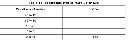
Complete the color key in Table 1. Use this key as a guide to color the elevations on the contour map. The colors should show good contrast. For example, use a variety of colors so that you can see the difference from one level to the next.
- What does the color-coded map show? Students should be able to use their color key to see changes in elevation.
- How is the northern hemisphere different from the southern hemisphere? Students should be able to see that the northern hemisphere is generally lower than the southern hemisphere.
- Compare your map with the color US Geological Survey map. How can colors help you find mountains and valleys? Answers will vary. Students should compare their color key with the USGS color key for the high elevations of mountains and low elevations of valleys.
- How many mountain peaks can you find? Students should be able to locate six to eight mountain peaks on the small scale map. These are shield volcanoes.
- What is the latitude, longitude and elevation of the highest peak? What is it called? The highest peak is located at approximately 16 degrees north, 10 degrees west. It is more than 25 kilometers high and is called Olympus Mons.
Note to teacher: On Mars, the longitude extends from 0 degrees to 360 degrees west.
- Use the map scale to measure the width of this mountain at the 5 kilometer level. Use the map scale for 20 degrees, which is 1 millimeter = 49 kilometers. The mountain at 5 kilometers is approximately 12 millimeters across or 588 kilometers wide.
- What do you think made the mountain peaks on Mars? Students may need prompting to suggest that volcanoes made these mountain peaks.
- What is the elevation, shape and name of the lowest feature on Mars? Hellas Planitia is deeper than -4 kilometers. It is a large, round basin or crater.
- What do you think made this feature? Students may need prompting to suggest that an extraterrestrial impact formed this huge crater.
- If Mars had seas, where would they be? Most of the Martian surface that lies below 0 kilometers-the point from which elevation is measured that corresponds to Earth's sea level-is in the northern hemisphere. The Hellas basin appears to be the only place in the southern hemisphere that is below 0 kilometers.
Elaboration
The enclosed maps of Mars have a scale of 1 to 52 million. Students might compare this scale to USGS topographic maps of Earth, many of which have scales of 1 to 24,000 (1:24,000) or 1 to 62,500 (1:62,500). You might compare the contour interval of 20 feet on the Earth topographic maps to contour intervals of 1 kilometer on the Mars maps (1 kilometer = 0.62 mile).
Students can also practice interpreting topographic maps with maps of their community. They can locate their school and use the map scale to measure the distances between the school and their homes.
This activity is designed to introduce students to the martian landscape. We selected the features on the topographic map as common large landforms that students will begin to recognize in later activities. The Hellas Planitia impact basin was visible in the last image taken by Mars Observer when it was 5.8 million kilometers away from Mars. Compare the black and white image with the MarsLink poster by artist Michael Carroll. The poster art was completed before the image was transmitted. It was by chance that the poster and Mars Observer image show about the same hemisphere of Mars. Students should be able to locate the dark Syrtis region and the lighter Hellas Planitia in both.
You might want to expand this activity by introducing the Latin names for Mars landforms (see Table 2 below). You can ask students to locate a mons, tholus, or planitia and describe what an explorer would see at that place.

Evaluation
Students will:
- Find the highest elevation on Mars and suggest what that landform might be.
- Locate an isolated plateau or highlands in the northern hemisphere.
- Use the map scale from the topographic map of Mars to measure the length of Valles Marineris.
- Color-code a topographic map of their community to share with their friends.
- Suggest what they might see from the rim of Hellas Planitia.